Maps are everywhere in fantasy–they’re at the front of books, they’re given to players at the start of TTRPG campaigns, they’re used for combat, puzzles, and much more. Maps are inspiring. They ground us more heavily in the world. A map can make a world feel more legitimate–more real. It gives structure to the structure, geography, topography, and order to an otherwise fantastical or otherworldly realm.
We’ve seen this not just as TTRPG gamers, but even foundational works of literature like Dante’s canticles Inferno, Purgatorio, and Paradiso–works describing divine and fantasy realms outside of human scope were mapped artistically as far back as the 1400s by artistic mastermind Botticelli.
We’ve seen it in foundational fantasy tales like The Hobbit and The Lord of The Rings by J.R.R. Tolkien, and we’ve seen them in mystical and religious works from several different parts of the world in the form of cosmological canon.

There’s obviously a deep-rooted yearning to map the fantastic, but I believe that a lot of the modern-day use of maps in TTRPG games that I’ve played in are lacking in the following ways: perspective, definition, medium, and content.
Perspective
When you look up “map” on Google, the first things to populate are omniscient views of our world. We have views of countries with defined borders like the 38th and 49th Parallels, we can see the vastness of oceans and mountains, and compare neighboring countries with incredible scope. Hell, within countries, we can see their states–all 50 for the USA.
I think there is a huge allure to make a hype realistic, omniscient, scientific, geographically accurate map of fantasy worlds. I know because I’ve done it before. There’s hundreds of websites that can allow you to make different maps in the style of what we are used to–we, as people living in the 21st century. Maps tell us what is important. Borders are important–we live in a time unlike most others in history where there are nation-states with closely monitored and defined borders. This gives us shape and accuracy. We value the nation-state, our countries. We value accuracy and science.
But what is important to the mapmakers of our TTRPG games? What’s important to those people?
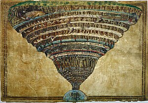
Let’s take a look at an older time in real life. What do you think was important to the mapmaker here:

Clearly not Ireland.
Joking aside, we can definitely tell what isn’t important: shape, borders, scientific and geographical accuracy.
What is? Jerusalem for one thing. It’s right in the middle, it has a different shape (it’s the only circle), and while there are other illustrations of cities, none are so impressive or defined as Jerusalem–with the only close contender being Rome.
Rome is clearly the second biggest city, yet we can tell by the the text in the margins and labels of landmarks, that this map if of German make (or audience). It is also accompanied by a number: 382. This was the year of Council of Rome which set the canon of old and new testament scripture.
Let’s replace Rome with another city from your world. What does the 382 mean now? Was it when it was founded? When it put in place a new government? When a powerful prophet had an oracular vision?
The map’s details (and lack there of) tell us a lot about what was important to the mapmaker and the culture the mapmaker hails from.
Now imagine this map in your D&D world, or a published setting that you love. What would be in the middle? How many leaves would there be? Which cities or regions would make the mapmaker’s cut, and which ones end up like Ireland (and even more notably, China)? What numbers would there be; are they dates; are they of numerological significance? What creatures do they draw in the sea?
This also gives an opportunity to prompt player’s curiosity. What do the numbers mean (, Mason)? Is this really all that is out there? is there an unknown or unmapped area of the world?
While more granular, scientific versions of our fantasy world can be created more easily now than ever, they can be very anachronistic and not as mystical or inspiring as some other choices.
Definition
The granularity of maps is also something that is common for modern maps, but might not fit the genre or be as inspiring for TTRPGs.
There are tons of maps from the fantasy and fiction that do not have a ton of definition, but they are still useful items for the adventurers.
Treasure maps are ones that really come to mind from fiction. Swashbuckling pirates trying to find a hidden cave or the ‘X’ deep in a jungle is a common and evocative trope.
In real life, the Inuit people made carvings of shoreline into wood. While not terribly high definition, it was a useful navigating tool for hunters.


While you could use something like this in a handout, this would also be a cool, helpful mundane item for the players to use and figure out over the course of a campaign. Furthermore, it could be the way that several civilizations and creatures choose to map, whether they be a collection of druids, traders who have a large access to wood or a woodworking culture, an alternate way to communicate information during wartime for a kingdom. The options are limitless.
Medium
The above Inuit coastline map is also a delve into what kind of medium a map is.
In current year, obviously a lot of the hyper realistic fantasy maps will be either shown digitally or printed for players in a handout, but aside from that, how do the players receive the information, or what are they looking at in the handout or the digital rendering?
In a desert setting, would they set stones in the sand to show where buildings, towns, temples, and oases are? Would a steampunk society etch the maps into metal plates?
When I personally imagine a map as an object, I think of something on paper, but in a fantastical setting, it can be fun to flip ordinary items on their head and add a little pizzazz!
Content
In Arabia, travelers often used the stars to guide them to their destinations, avoiding the sweltering heat of the daytime desert. Today, in aviation, we use wind charts to help us travel long distance, or to temper expectations as to when we will arrive at our destination.
What do the people in your world map? Do they navigate by the stars because traveling during the day is dangerous? Do they map the stars because they constantly change or give omens. Do airships use jet waves to get places faster?
In the modern day, we map roadways. I use GPS all the time to get where I need to go, even in familiar areas, but 200 years ago, waterways, rivers, lakes, and coastlines would have been more useful traveling long distances than trails.
Conclusion
While the omniscient worldview that we can now generate is sexy and tantalizing, they are anachronistic and a severely modern take on what maps are. Taking a look at the history of maps from different time periods, cultures, and regions allows us to be more flavorful and fantastical about how people view the world not just from a geographical perspective.